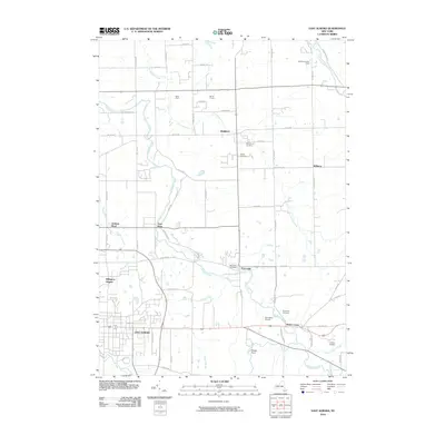
2010 Map of East Aurora
USGS Topo · Published 2010About this map
East Aurora serves as the primary anchor for this Erie County landscape, where the street grid of the village transitions into the agricultural reaches of Marilla and Wales Center. The drainage of Buffalo Creek and its many tributaries, including Little Buffalo Creek and Tannery Brook, dictates the placement of long-established settlements such as Porterville and East Elma. This 2010 survey shows a late-twentieth-century residential footprint expanding into traditional farmland, notably at Billington Heights and around the Jamison Road area. Local history is traced through a series of burial grounds like Maplewood Cemetery and Evergreen Cemetery, while landmarks such as Donnellys Airport and family-named operations like Miller Farm and Berner Farms reflect the enduring mix of general aviation and rural commerce. To the north and east, seasonal or specialized sites like Depew-Lancaster Camp and Camp Aloha indicate the area's role in regional recreation.
Find a feature on this map
63 named features on this map. Tap any name to fly to it.
Don’t see what you’re looking for? This feature index may not catch every label — zoom into the map to look around manually.
Map Details
Editions of this 2010 East Aurora Map
This is the sole edition of this map. No revisions or reprints were ever made.
Other maps of this area

1905 · Attica
USGS Topo · 1:62,500

1905 · Depew
USGS Topo · 1:62,500

1923 · Arcade
USGS Topo · 1:62,500

1925 · Springville
USGS Topo · 1:62,500

1925 · Arcade
USGS Topo · 1:62,500

1948 · Depew
USGS Topo · 1:62,500

1949 · Attica
USGS Topo · 1:62,500

1949 · Cowlesville
USGS Topo · 1:24,000
1950 · Corfu
USGS Topo · 1:24,000
1950 · Lancaster
USGS Topo · 1:24,000