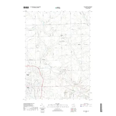
2019 Map of East Aurora
USGS Topo · Published 2019About this map
East Aurora serves as a primary hub in this suburban and rural landscape east of Buffalo, where the grid of modern development meets the winding paths of western New York's waterways. The village's street plan, centered on Main St, gives way to outlying hamlets like Wales Center and Marilla, reflecting the region's enduring settlement patterns. The terrain is deeply defined by the drainage of Buffalo Creek and its many tributaries, including Little Buffalo Cr and Cayuga Creek. These watercourses carve through the landscape, creating distinctive topography such as Mossy Point. Local heritage is preserved in several burial grounds across the townships, including Evergreen Cem and Maple Rest Cem, providing clear points of reference for genealogists. The map captures a mix of residential clusters like Billington Heights and the transition into more open country toward the eastern edge of the quadrangle.
Find a feature on this map
103 named features on this map. Tap any name to fly to it.
Don’t see what you’re looking for? This feature index may not catch every label — zoom into the map to look around manually.
Map Details
Editions of this 2019 East Aurora Map
This is the sole edition of this map. No revisions or reprints were ever made.
Other maps of this area

1905 · Attica
USGS Topo · 1:62,500

1905 · Depew
USGS Topo · 1:62,500

1923 · Arcade
USGS Topo · 1:62,500

1925 · Springville
USGS Topo · 1:62,500

1925 · Arcade
USGS Topo · 1:62,500

1948 · Depew
USGS Topo · 1:62,500

1949 · Attica
USGS Topo · 1:62,500

1949 · Cowlesville
USGS Topo · 1:24,000
1950 · Corfu
USGS Topo · 1:24,000
1950 · Lancaster
USGS Topo · 1:24,000