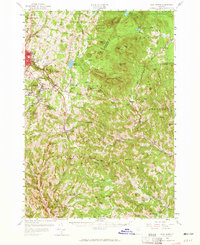
1957 Map of East Barre
USGS Topo · Published 1965About this map
Barre and its surrounding granite-rich hills dominate the western edge of this landscape, where the industry is marked by numerous Quarries and specialized settlements like Graniteville and Websterville. The terrain rises eastward into the Knox Mountains, a series of high peaks including Butterfield Mtn and Signal Mtn that define the watershed between the Jail Branch and the Waits River. This rugged upland geography necessitated the construction of the East Barre Dam to manage the heavy drainage from the Orange Brook and Trow Brook systems.
Find a feature on this map
121 named features on this map. Tap any name to fly to it.
Don’t see what you’re looking for? This feature index may not catch every label — zoom into the map to look around manually.
Map Details
Editions of this 1957 East Barre Map
4 editions found
Other maps of this area

1896 · Strafford
USGS Topo · 1:62,500

1919 · Royalton
USGS Topo · 1:62,500

1919 · Montpelier
USGS Topo · 1:62,500

1921 · Montpelier
USGS Topo · 1:62,500

1922 · Barre
USGS Topo · 1:48,000

1924 · Barre
USGS Topo · 1:62,500

1924 · Randolph
USGS Topo · 1:48,000

1926 · Randolph
USGS Topo · 1:62,500

1931 · Mt. Cube
USGS Topo · 1:62,500

1931 · Woodsville
USGS Topo · 1:48,000