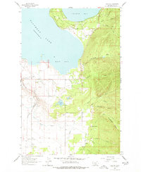
1964 Map of East Bay
USGS Topo · Published 1977About this map
Flathead Lake dominates the western landscape of this 1964 survey, where the prominent peninsula of Finley Point separates Skidoo Bay from the larger waters of East Bay. The region's agricultural and industrial infrastructure is clearly defined, showing a complex network of water management including the Polson Canal, the Pablo Feeder Canal, and the Bousquet Ditch. These irrigation features supported the developing lands east of the Northern Pacific railroad line, which skirts the western edge of the map.
Find a feature on this map
32 named features on this map. Tap any name to fly to it.
Don’t see what you’re looking for? This feature index may not catch every label — zoom into the map to look around manually.
Map Details
Editions of this 1964 East Bay Map
2 editions found
Other maps of this area

1920 · Flathead Lake
USGS Topo · 1:125,000

1955 · Choteau
USGS Topo · 1:250,000

1956 · Wallace
USGS Topo · 1:250,000

1957 · Choteau
USGS Topo · 1:250,000

1958 · Choteau
USGS Topo · 1:250,000

1960 · Wallace
USGS Topo · 1:250,000

1962 · Choteau
USGS Topo · 1:250,000

1964 · Bull Island
USGS Topo · 1:24,000

1964 · Wild Horse Island
USGS Topo · 1:24,000

1964 · East Bay
USGS Topo · 1:24,000