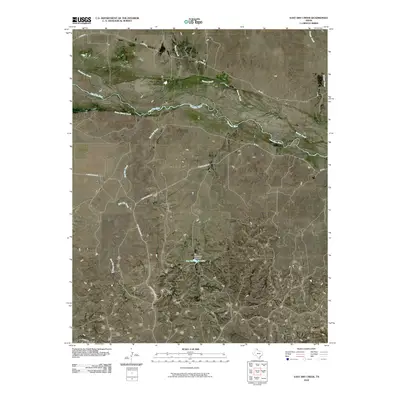
2010 Map of East Dry Creek
USGS Topo · Published 2010About this map
The Canadian River carves a broad path across this Roberts County landscape, creating a complex network of braided channels and sandbars characteristic of the Texas Panhandle. This 2010 survey highlights the hydrological features that dominate the region, including the confluence of Home Ranch Creek and Barton Creek with the main river valley. To the south, the topography is defined by the drainage of East Dry Creek, which feeds toward the substantial Jim Waterfield Lake. This reservoir and the Jim Waterfield Lake Dam represent significant water management infrastructure in an otherwise arid ranching environment. The local road network, including Quarter Horse Rd and N River Rd, follows the natural contours of the river valley, providing access to remote cattle ranching operations and family-owned lands throughout the quadrangle.
Find a feature on this map
16 named features on this map. Tap any name to fly to it.
Don’t see what you’re looking for? This feature index may not catch every label — zoom into the map to look around manually.
Map Details
Editions of this 2010 East Dry Creek Map
This is the sole edition of this map. No revisions or reprints were ever made.
Other maps of this area

1954 · Perryton
USGS Topo · 1:250,000

1954 · Amarillo
USGS Topo · 1:250,000

1958 · Perryton
USGS Topo · 1:250,000

1958 · Amarillo
USGS Topo · 1:250,000

1967 · Mendota
USGS Topo · 1:24,000

1972 · Washburn Arroyo
USGS Topo · 1:24,000

1972 · Horse Creek North
USGS Topo · 1:24,000

1972 · Canadian West
USGS Topo · 1:24,000

1972 · East Dry Creek
USGS Topo · 1:24,000
1972 · Horse Creek South
USGS Topo · 1:24,000