
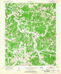
1953 Map of East Fork
USGS Topo · Published 1955About this map
The East Fork Little Barren River carves a winding path through this central Kentucky landscape, defining the rural character of Metcalfe, Green, and Adair counties in the early 1950s. The map reveals a highly decentralized network of small family-centered communities, where life revolved around local landmarks like Union Chapel and Foundation Ch. The distribution of numerous one-room schools, such as Mud Slash Sch and White Oak Sch, suggests a population density that still relied on walking distance for education and communal gathering before the full consolidation of rural districts.
Find a feature on this map
50 named features on this map. Tap any name to fly to it.
Don’t see what you’re looking for? This feature index may not catch every label — zoom into the map to look around manually.
Map Details
Editions of this 1953 East Fork Map
2 editions found
Other maps of this area

1953 · Gradyville
USGS Topo · 1:24,000

1953 · Sulphur Well
USGS Topo · 1:24,000

1953 · Breeding
USGS Topo · 1:24,000

1953 · Edmonton
USGS Topo · 1:24,000

1953 · Summer Shade
USGS Topo · 1:24,000

1953 · Exie
USGS Topo · 1:24,000

1953 · Gresham
USGS Topo · 1:24,000

1953 · Center
USGS Topo · 1:24,000

1956 · Corbin
USGS Topo · 1:250,000

1957 · Winchester
USGS Topo · 1:250,000