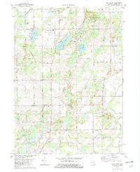
1982 Map of East Leroy
USGS Topo · Published 1982About this map
East Leroy and the surrounding agricultural landscape of southern Michigan are captured here in a 1982 update of the regional topography. The map reveals a transition in land use, where traditional farming and rural settlements like Joppa and Morgan Corners coexist with recreational developments such as Charles Binder Park and its Golf Course. The legacy of 19th-century transport is still visible in the Old RR Grade that cuts north-south through the center of the sheet, providing a clear path for genealogists tracing former rail alignments.
Find a feature on this map
66 named features on this map. Tap any name to fly to it.
Don’t see what you’re looking for? This feature index may not catch every label — zoom into the map to look around manually.
Map Details
Editions of this 1982 East Leroy Map
This is the sole edition of this map. No revisions or reprints were ever made.
Other maps of this area

1918 · Battle Creek
USGS Topo · 1:62,500

1918 · Union City
USGS Topo · 1:62,500

1918 · Galesburg
USGS Topo · 1:62,500

1918 · Leonidas
USGS Topo · 1:62,500

1943 · Battle Creek
USGS Topo · 1:62,500

1944 · Leonidas
USGS Topo · 1:62,500

1944 · Galesburg
USGS Topo · 1:62,500

1947 · Augusta
USGS Topo · 1:24,000

1947 · Ceresco
USGS Topo · 1:24,000

1947 · Battle Creek
USGS Topo · 1:24,000