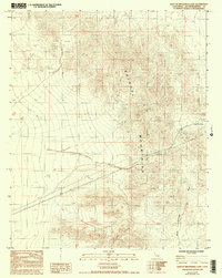
1985 Map of East of Broadwell Lake
USGS Topo · Published 1993About this map
The Bristol Mountains dominate this arid portion of San Bernardino County, revealing a landscape defined by industrial infrastructure and mineral exploration in the mid-1980s. A high-voltage Trans Line and a long-distance Pipeline cut across the alluvial fans and complex topography, illustrating the region's role as a corridor for utility transport. Evidence of small-scale mining activity is scattered through the northern terrain, where several sites are marked simply as Prospect or Prospects. These labels, alongside the ephemeral drainage patterns of a large Wash, highlight the isolation and the specific economic interests that drew surveyors to this corner of the Mojave Desert. The map serves as a record of these industrial footprints before later shifts in land use or environmental designations.
Find a feature on this map
7 named features on this map. Tap any name to fly to it.
Don’t see what you’re looking for? This feature index may not catch every label — zoom into the map to look around manually.
Map Details
Editions of this 1985 East of Broadwell Lake Map
4 editions found
Other maps of this area

1942 · Amboy
USGS Topo · 1:250,000

1943 · Amboy
USGS Topo · 1:250,000

1953 · San Bernardino
USGS Topo · 1:250,000

1954 · Needles
USGS Topo · 1:250,000

1955 · Ludlow
USGS Topo · 1:24,000

1955 · Ash Hill
USGS Topo · 1:24,000

1955 · Broadwell Lake
USGS Topo · 1:62,500

1955 · Ludlow
USGS Topo · 1:62,500

1956 · San Bernardino
USGS Topo · 1:250,000

1956 · Needles
USGS Topo · 1:250,000