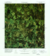
1977 Map of East of Cannon Corners Station
USGS Topo · Published 1978About this map
English River and its numerous tributaries, including Mooer Brook and Robson Brook, dominate this landscape along the international border in northern Clinton County. The map illustrates a rural borderland where small settlements like Corbin, Frontier, and Cannon Corners are connected by a network of local roads such as Kellas Road and Telephone Road. The southern edge of the sheet is anchored by the community of Mooers Forks and the course of the Great Chazy River. This 1970s aerial survey, produced in cooperation with the U. S. Customs Service, highlights the intersection of natural watercourses and the straight line of the Canada United States boundary. For researchers, the presence of the Walker Cem and an Old Railroad Grade near the river suggests early transit corridors and local family history sites that predate the modern road system.
Find a feature on this map
34 named features on this map. Tap any name to fly to it.
Don’t see what you’re looking for? This feature index may not catch every label — zoom into the map to look around manually.
Map Details
Editions of this 1977 East of Cannon Corners Station Map
This is the sole edition of this map. No revisions or reprints were ever made.
Other maps of this area

1895 · Mooers
USGS Topo · 1:62,500

1899 · Mooers
USGS Topo · 1:62,500

1915 · Churubusco
USGS Topo · 1:62,500

1942 · Mooers
USGS Topo · 1:62,500

1943 · Churubusco
USGS Topo · 1:62,500

1943 · Mooers
USGS Topo · 1:62,500

1950 · Lake Champlain
USGS Topo · 1:250,000
1956 · Mooers
USGS Topo · 1:62,500

1958 · Lake Champlain
USGS Topo · 1:250,000

1962 · Lake Champlain
USGS Topo · 1:250,000