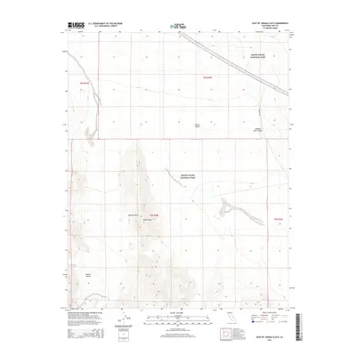
2015 Map of East of Joshua Flats
USGS Topo · Published 2015About this map
Death Valley National Park encompasses much of this desert landscape, where the high ridges of the Saline Range overlook the broad expanse of the Eureka Valley. The area is defined by dramatic topographical shifts, falling away from mountain crests into the deep incisions of Marble Canyon and Hanging Rock Canyon. This 2015 survey illustrates the isolation of the Mojave Desert interior, where human infrastructure is limited to the lone track of S Eureka Rd cutting through the northern basins. The map serves as a detailed record of the natural drainage patterns and alluvial fans that shape the valley floor, providing a precise look at the transition between the park's protected wilderness and the surrounding public lands.
Find a feature on this map
11 named features on this map. Tap any name to fly to it.
Don’t see what you’re looking for? This feature index may not catch every label — zoom into the map to look around manually.
Map Details
Editions of this 2015 East of Joshua Flats Map
This is the sole edition of this map. No revisions or reprints were ever made.
Other maps of this area
1908 · Lida
USGS Topo · 1:250,000
1913 · Lida
USGS Topo · 1:250,000

1954 · Goldfield
USGS Topo · 1:250,000
1955 · Goldfield
USGS Topo · 1:250,000
1957 · Magruder Mtn
USGS Topo · 1:62,500
1958 · Goldfield
USGS Topo · 1:250,000
1958 · Last Chance Range
USGS Topo · 1:62,500
1958 · Soldier Pass
USGS Topo · 1:62,500
1958 · Waucoba Spring
USGS Topo · 1:62,500
1962 · Goldfield
USGS Topo · 1:250,000