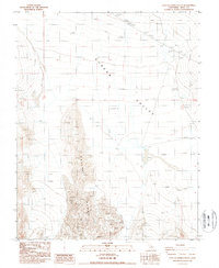
1987 Map of East of Joshua Flats
USGS Topo · Published 1987About this map
Saline Range summits dominate the southwestern portion of this Inyo County terrain, where the high desert peaks drop sharply toward the floor of the Eureka Valley. This 1980s provisional survey documents a landscape defined by dramatic elevation changes and arid landforms, including several clusters of Sand Dunes near the mountain foothills. Human presence is sparse, marked primarily by utilitarian infrastructure such as a Borrow Pit in the northern reaches and a Dry Well situated on the valley floor. Transportation is limited to a single 4wd track, suggesting the area remained difficult to access and primarily used for small-scale resource extraction or remote navigation during this era.
Find a feature on this map
9 named features on this map. Tap any name to fly to it.
Don’t see what you’re looking for? This feature index may not catch every label — zoom into the map to look around manually.
Map Details
Editions of this 1987 East of Joshua Flats Map
This is the sole edition of this map. No revisions or reprints were ever made.
Other maps of this area

1908 · Lida
USGS Topo · 1:250,000

1913 · Lida
USGS Topo · 1:250,000

1954 · Goldfield
USGS Topo · 1:250,000

1955 · Goldfield
USGS Topo · 1:250,000

1957 · Magruder Mtn
USGS Topo · 1:62,500

1958 · Goldfield
USGS Topo · 1:250,000

1958 · Last Chance Range
USGS Topo · 1:62,500

1958 · Soldier Pass
USGS Topo · 1:62,500
1958 · Waucoba Spring
USGS Topo · 1:62,500

1962 · Goldfield
USGS Topo · 1:250,000