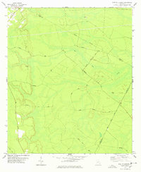
1978 Map of East Of Ludowici
USGS Topo · Published 1978About this map
Bull Town Swamp dominates the low-lying interior of this coastal Georgia landscape, where the borders of Liberty, Long, and McIntosh counties converge. The 1970s terrain is characterized by a network of timber and access roads, including Warsaw Tram Road and Footpiece Road, which navigate through dense wetlands and isolated high points like Jonas Island. Small family landmarks such as Middleton Cem and Branson Cem are preserved here, providing valuable reference points for genealogists researching the rural communities near Brickston. A notable portion of the landscape is designated as a Bombing Range, reflecting the military presence integrated into the local land use. The presence of a Sandpit and various named tracks like Bobtown Road suggest a rural economy tied to resource extraction and forest management during this era.
Find a feature on this map
21 named features on this map. Tap any name to fly to it.
Don’t see what you’re looking for? This feature index may not catch every label — zoom into the map to look around manually.
Map Details
Editions of this 1978 East Of Ludowici Map
This is the sole edition of this map. No revisions or reprints were ever made.
Other maps of this area

1918 · Hinesville
USGS Topo · 1:62,500

1920 · Sapelo River
USGS Topo · 1:62,500

1920 · Limerick
USGS Topo · 1:62,500

1943 · Ludowici
USGS Topo · 1:62,500

1943 · Sapelo River
USGS Topo · 1:62,500

1944 · Hinesville
USGS Topo · 1:62,500

1944 · Limerick
USGS Topo · 1:62,500

1945 · Sapelo River
USGS Topo · 1:62,500

1946 · Brunswick
USGS Topo · 1:250,000

1948 · Brunswick
USGS Topo · 1:250,000