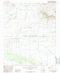
1986 Map of East of Old Leupp
USGS Topo · Published 1986About this map
The Little Colorado River winds through the southern reaches of the Navajo Indian Reservation on this 1980s-era survey, a landscape defined by seasonal drainages and industrial infrastructure. Broad washes, including Pollacca Wash and Jadito Wash, cut across the terrain to meet Corn Creek in the northwest. The presence of a Pumping Sta and multiple pipelines crossing the central plateau indicates the region's importance for resource transport. Near these utility lines, a remote Landing Strip and a solitary Corral mark the sparse human footprint in this high desert environment, where Coconino and Navajo counties meet. The map captures a moment when traditional land use and modern energy corridors overlapped in the high plateau country.
Find a feature on this map
11 named features on this map. Tap any name to fly to it.
Don’t see what you’re looking for? This feature index may not catch every label — zoom into the map to look around manually.
Map Details
Editions of this 1986 East of Old Leupp Map
This is the sole edition of this map. No revisions or reprints were ever made.
Other maps of this area

1883 · Tusayan
USGS Topo · 1:250,000

1886 · Tusayan
USGS Topo · 1:250,000

1947 · Flagstaff
USGS Topo · 1:250,000

1954 · Winslow
USGS Topo · 1:62,500

1954 · Winslow 4 NW
USGS Topo · 1:24,000

1954 · Flagstaff
USGS Topo · 1:250,000

1955 · Winslow 2 SW
USGS Topo · 1:24,000

1955 · Leupp
USGS Topo · 1:62,500

1957 · Winslow 1 SW
USGS Topo · 1:24,000
1957 · Winslow 2 SE
USGS Topo · 1:24,000