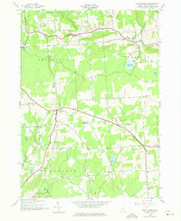
1943 Map of East Pharsalia
USGS Topo · Published 1975About this map
North Pharsalia and East Pharsalia anchor this rural Chenango County landscape as it appeared during the early 1940s. The region is defined by its network of high-elevation headwaters and small settlements, where upland farming and timber harvesting supported the local economy. Significant landmarks such as Berry Hill and the Pharsalia Game Refuge dominate the northern terrain, while a series of numbered district schools, including School No 10 and School No 1, reflect a decentralized rural education system typical of the era. Genealogists can locate several small family burial grounds like Frink Cem and Lewis Cem scattered along the winding roads. The map also traces several important waterways like Canasawacta Creek and Genegantslet Creek, which drain these hills. The presence of the Plymouth Reservoir and isolated basins like Steer Pond highlights the importance of water management in this high-altitude dairy-farming belt.
Find a feature on this map
32 named features on this map. Tap any name to fly to it.
Don’t see what you’re looking for? This feature index may not catch every label — zoom into the map to look around manually.
Map Details
Editions of this 1943 East Pharsalia Map
3 editions found
Other maps of this area

1902 · Coventry
USGS Topo · 1:62,500

1903 · Norwich
USGS Topo · 1:62,500

1904 · Greene
USGS Topo · 1:62,500

1904 · Oxford
USGS Topo · 1:62,500

1904 · Pitcher
USGS Topo · 1:62,500

1943 · Otselic
USGS Topo · 1:24,000

1943 · South Ostelic
USGS Topo · 1:24,000

1943 · Norwich
USGS Topo · 1:24,000

1943 · East Pharsalia
USGS Topo · 1:24,000
1943 · Earlville
USGS Topo · 1:24,000