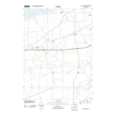
2010 Map of East Springfield
USGS Topo · Published 2010About this map
East Springfield and its neighboring hamlets sit just south of the Lake Erie shoreline, forming a corridor of settlements across northwestern Pennsylvania. This 2010 survey reveals a landscape where modern transportation routes, such as the major east-west highway, intersect with an older network of named corners and junctions. Small communities like Cherry Hill, Kidders Corner, and Knapps Corners are spaced along rural roads, reflecting a long history of local commerce at crossroads.
Find a feature on this map
70 named features on this map. Tap any name to fly to it.
Don’t see what you’re looking for? This feature index may not catch every label — zoom into the map to look around manually.
Map Details
Editions of this 2010 East Springfield Map
This is the sole edition of this map. No revisions or reprints were ever made.
Other maps of this area

1900 · Girard
USGS Topo · 1:62,500

1900 · Fairview
USGS Topo · 1:62,500

1906 · Conneaut
USGS Topo · 1:62,500

1950 · Cleveland
USGS Topo · 1:250,000

1950 · Erie
USGS Topo · 1:250,000

1956 · Cleveland
USGS Topo · 1:250,000

1957 · Fairview SW
USGS Topo · 1:24,000
1957 · Fairview
USGS Topo · 1:24,000

1959 · Conneautville
USGS Topo · 1:24,000

1959 · East Springfield
USGS Topo · 1:24,000