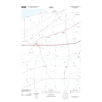
2013 Map of East Springfield
USGS Topo · Published 2013About this map
Lake Erie defines the northern edge of this Erie County landscape, where the shoreline and inland drainage basins shape a network of small settlements and transit corridors. The area is anchored by the trio of West Springfield, East Springfield, and North Springfield, established along historic routes like W Ridge Rd and W Lake Rd. Further inland, the map captures a pattern of local junctions and family-named corners such as Egley Corners, Kidders Corner, and Knapps Corners. The terrain is deeply etched by the meandering Conneaut Cr and Raccoon Cr, which flow toward the Great Lake through a patchwork of agricultural lands and woodlots. Notable landmarks include the recreational grounds at Camp Lambec near the shore and the G & N Airport in the southeastern quadrant, illustrating the blend of rural residential life and specialized land use in this lakeside community.
Find a feature on this map
78 named features on this map. Tap any name to fly to it.
Don’t see what you’re looking for? This feature index may not catch every label — zoom into the map to look around manually.
Map Details
Editions of this 2013 East Springfield Map
This is the sole edition of this map. No revisions or reprints were ever made.
Other maps of this area

1900 · Girard
USGS Topo · 1:62,500

1900 · Fairview
USGS Topo · 1:62,500

1906 · Conneaut
USGS Topo · 1:62,500

1950 · Cleveland
USGS Topo · 1:250,000

1950 · Erie
USGS Topo · 1:250,000

1956 · Cleveland
USGS Topo · 1:250,000

1957 · Fairview SW
USGS Topo · 1:24,000
1957 · Fairview
USGS Topo · 1:24,000

1959 · Conneautville
USGS Topo · 1:24,000

1959 · East Springfield
USGS Topo · 1:24,000