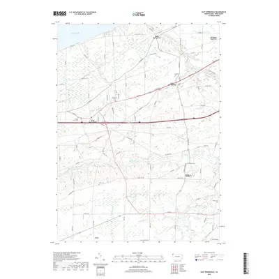
2019 Map of East Springfield
USGS Topo · Published 2019About this map
Lake Erie defines the northern coastline of this Erie County landscape, where the settlements of North Springfield, East Springfield, and West Springfield follow the established routes of W Lake Rd and Ridge Rd. This survey captures the transition from the lakeside bluffs down to the meandering path of Conneaut Creek as it cuts through the southern interior. Genealogists and local historians can find several established burial grounds, including Springfield Cem, Cottage Church Cem, Salsbury Cem, and Griffey Cem, which reflect the community's ancestral footprint. The area's transportation and small-town character are further illustrated by the presence of Thornton Junction and the G & N Airport, alongside the numerous local roads that connect family-named landmarks and historical crossroads like Kidders Corner.
Find a feature on this map
82 named features on this map. Tap any name to fly to it.
Don’t see what you’re looking for? This feature index may not catch every label — zoom into the map to look around manually.
Map Details
Editions of this 2019 East Springfield Map
This is the sole edition of this map. No revisions or reprints were ever made.
Other maps of this area

1900 · Girard
USGS Topo · 1:62,500

1900 · Fairview
USGS Topo · 1:62,500

1906 · Conneaut
USGS Topo · 1:62,500

1950 · Cleveland
USGS Topo · 1:250,000

1950 · Erie
USGS Topo · 1:250,000

1956 · Cleveland
USGS Topo · 1:250,000

1957 · Fairview SW
USGS Topo · 1:24,000
1957 · Fairview
USGS Topo · 1:24,000

1959 · Conneautville
USGS Topo · 1:24,000

1959 · East Springfield
USGS Topo · 1:24,000