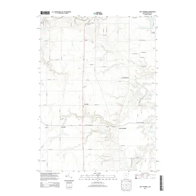
2013 Map of East Trumbull
USGS Topo · Published 2013About this map
Grand River meanders through this portion of Ashtabula County, anchoring a landscape defined by small rural settlements and a series of smaller water bodies like Lake George and Armington Lake. The area is characterized by its numerous historic burial grounds, including the Footville Cem and E Trumbull Cem, which serve as vital markers of the community's ancestral roots near Footville and East Trumbull. The north-south corridor of Oh-534 connects the hamlets of Cork and Trumbull, passing through a terrain punctuated by small farms like Still Waters Farm. In the eastern section, the Beaumonts Scout Reservation occupies the wooded land along Trumbull Cr, while Armington Airport sits near the northeastern boundary, providing a glimpse into the local infrastructure and land use patterns of the early twenty-first century.
Find a feature on this map
71 named features on this map. Tap any name to fly to it.
Don’t see what you’re looking for? This feature index may not catch every label — zoom into the map to look around manually.
Map Details
Editions of this 2013 East Trumbull Map
This is the sole edition of this map. No revisions or reprints were ever made.
Other maps of this area

1904 · Chardon
USGS Topo · 1:62,500

1905 · Ashtabula
USGS Topo · 1:62,500

1905 · Perry
USGS Topo · 1:62,500

1905 · Jefferson
USGS Topo · 1:62,500

1906 · Chardon
USGS Topo · 1:62,500

1907 · Jefferson
USGS Topo · 1:62,500

1950 · Cleveland
USGS Topo · 1:250,000

1956 · Cleveland
USGS Topo · 1:250,000
1959 · East Claridon
USGS Topo · 1:24,000
1959 · Windsor
USGS Topo · 1:24,000
Featured Places
- Morgan Township, OH
- Trumbull, Trumbull Township
- Trumbull Township, OH
- Hartsgrove Township, OH
- Austinburg Township, OH