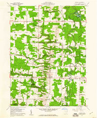
1959 Map of Windsor
USGS Topo · Published 1961About this map
Phelps Creek and the Grand River dictate the rural character of this late-1950s landscape, winding through a patchwork of woodland and agriculture in southern Ashtabula County. The settlement at Windsor sits as a central crossroads, while smaller hamlets like Windsor Mills and Stoneville preserve the historic distribution of local commerce. Genealogists can identify established burial grounds such as Pioneer Cem and the Southeast Hartsgrove Cemetery. The presence of Camp Whitewood near Hoskins Hollow suggests the mid-century development of recreational and youth spaces in the valley. Throughout the Hartsgrove and Windsor townships, an extensive network of named local roads—including Wiswell Road and Higley Road—connects scattered farmsteads, reflecting a period before significant suburban sprawl began to alter the township's traditional boundaries.
Find a feature on this map
49 named features on this map. Tap any name to fly to it.
Don’t see what you’re looking for? This feature index may not catch every label — zoom into the map to look around manually.
Map Details
Editions of this 1959 Windsor Map
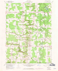
2 editions found
Other maps of this area

1904 · Chardon
USGS Topo · 1:62,500

1905 · Bristolville
USGS Topo · 1:62,500

1905 · Garrettsville
USGS Topo · 1:62,500

1905 · Jefferson
USGS Topo · 1:62,500

1906 · Chardon
USGS Topo · 1:62,500

1907 · Bristolville
USGS Topo · 1:62,500

1907 · Jefferson
USGS Topo · 1:62,500

1907 · Garrettsville
USGS Topo · 1:62,500

1950 · Cleveland
USGS Topo · 1:250,000

1952 · West Farmington
USGS Topo · 1:24,000
Featured Places
- Mesopotamia Township, OH
- Windsor, OH
- Hartsgrove Township, OH
- Hartsgrove, Hartsgrove Township
- Bloomfield Township, OH