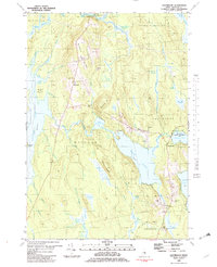
1981 Map of Eastbrook
USGS Topo · Published 1982About this map
Waltham Ridge and Hiller Ridge define the central spine of this Hancock County landscape, separating the lowlands of Graham Lake from the interior waters of Webb Pond. In the early 1980s, the rural communities of Waltham and Eastbrook remained centers of local life, anchored by landmarks such as the Cave Hill Sch and family resting places like Hillside Cem and Sunnyside Cem. The eastern portion of the quadrangle highlights the Lyle Frost Wildlife Management Area surrounding Scammon Pond, signaling a transition toward protected conservation lands. The map details an environment where human activity—seen in the scattered Gravel Pits and the Athletic Field—exists alongside extensive wetlands like Casebottle Heath and Mornison Heath.
Find a feature on this map
55 named features on this map. Tap any name to fly to it.
Don’t see what you’re looking for? This feature index may not catch every label — zoom into the map to look around manually.
Map Details
Editions of this 1981 Eastbrook Map
2 editions found
Other maps of this area

1911 · Ellsworth
USGS Topo · 1:62,500

1929 · Great Pond
USGS Topo · 1:48,000

1929 · Lead Mountain
USGS Topo · 1:48,000

1930 · Tunk Lake
USGS Topo · 1:48,000

1932 · Tunk Lake
USGS Topo · 1:62,500

1932 · Lead Mountain
USGS Topo · 1:62,500

1932 · Great Pond
USGS Topo · 1:62,500

1940 · Ellsworth
USGS Topo · 1:62,500

1942 · Ellsworth
USGS Topo · 1:62,500

1942 · Tunk Lake
USGS Topo · 1:62,500