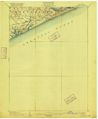
1904 Map of Easthampton
USGS Topo · Published 1916About this map
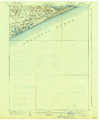
Maritime life and coastal agriculture define this corner of the South Fork as it was surveyed at the dawn of the twentieth century. The village of Easthampton serves as the hub for surrounding hamlets like Pantigo, Jericho, and Hardscrabble, while the Long Island (Montauk Division) railroad provides a critical artery stretching east toward the dunes. Along the ocean shore, a series of Life Saving Stations, including Georgica L.S.S. and Amagansett L.S.S., stand guard over the shifting sands of Napeague Beach. To the north, the landscape transitions into the fishing and processing grounds of Promised Land along Gardiners Bay. This era predates the intensive residential development of the modern Hamptons, showing a landscape of open terrain, ponds like Georgica Pond, and the scattered landings of Abrams Ldg. and Fresh Pond Ldg., where the local economy met the sea.
Find a feature on this map
25 named features on this map. Tap any name to fly to it.
Don’t see what you’re looking for? This feature index may not catch every label — zoom into the map to look around manually.
Map Details
Editions of this 1904 Easthampton Map
6 editions found
Other maps of this area

1903 · Sag Harbor
USGS Topo · 1:62,500

1903 · Gardiners Island
USGS Topo · 1:62,500

1904 · Sag Harbor
USGS Topo · 1:62,500

1904 · Shelter Island
USGS Topo · 1:62,500

1904 · Easthampton
USGS Topo · 1:62,500

1904 · Gardiners Island
USGS Topo · 1:62,500

1904 · Montauk
USGS Topo · 1:62,500

1921 · Gardiners Island
USGS Topo · 1:62,500

1921 · Easthampton
USGS Topo · 1:62,500
1942 · Montauk Point
USGS Topo · 1:24,000
Featured Places
- Southampton, NY
- East Hampton, NY
- Springs, East Hampton
- East Hampton North, East Hampton
- Northwest Harbor, East Hampton