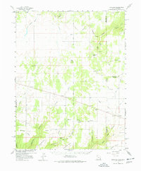
1957 Map of Eastland
USGS Topo · Published 1978About this map
Eastland and Lockerby sit within a high-elevation landscape of deep canyons and prominent mesas along the border of Utah and Colorado in the late 1950s. The region is defined by complex drainage systems like Summit Canyon, Boulder Canyon, and Horsehead Canyon that cut through the terrain toward Piute Creek and Coal Bed Creek. A network of unpaved routes, including East Summit Road and West Summit Road, connects the rural settlements and local institutions such as East Summit School and Burn School. Evidence of local industry and infrastructure is visible through a prominent Pipeline and a mining Shaft, while community life is anchored by landmarks like Valley View Cemetery and Roadside Park. Grounded in work by the U.S. Geological Survey with cooperation from the Atomic Energy Commission, the map details a period of topographical survey using early 1950s aerial photography to document this sparsely populated agricultural and mining frontier.
Find a feature on this map
59 named features on this map. Tap any name to fly to it.
Don’t see what you’re looking for? This feature index may not catch every label — zoom into the map to look around manually.
Map Details
Editions of this 1957 Eastland Map
4 editions found
Other maps of this area

1885 · La Sal
USGS Topo · 1:250,000

1886 · Abajo
USGS Topo · 1:250,000

1892 · Abajo
USGS Topo · 1:250,000

1893 · Abajo
USGS Topo · 1:250,000

1916 · Paradox Valley
USGS Topo · 1:125,000

1922 · Paradox Valley
USGS Topo · 1:125,000

1948 · Horse Range Mesa
USGS Topo · 1:24,000

1949 · Egnar
USGS Topo · 1:24,000

1950 · Horse Range Mesa
USGS Topo · 1:24,000

1950 · Egnar
USGS Topo · 1:24,000