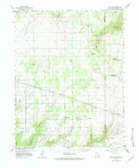
1957 Map of Eastland
USGS Topo · Published 1984About this map
Eastland and the nearby agricultural outpost of Lockerby serve as focal points for this high-desert landscape on the border of Utah and Colorado. The map reveals a transition from the plateau's dry-farming fields to a complex network of canyons, including Montezuma Canyon and Piute Canyon, where topography dictated early settlement patterns. This 1950s survey was produced in cooperation with the Atomic Energy Commission, hinting at the era's regional uranium prospecting interest, although the landscape here remains largely rural and dominated by ranching and local infrastructure. Genealogists will find several landmarks of community life, such as the East Summit School, Valley View Cemetery, and the Burn School Cem. Prominent terrain features like Piute Knoll and Ginger Hill provided essential orientation for residents navigating the mesa tops between deep incisions like Coal Bed Creek and Wildhorse Canyon.
Find a feature on this map
49 named features on this map. Tap any name to fly to it.
Don’t see what you’re looking for? This feature index may not catch every label — zoom into the map to look around manually.
Map Details
Editions of this 1957 Eastland Map
4 editions found
Other maps of this area

1885 · La Sal
USGS Topo · 1:250,000

1886 · Abajo
USGS Topo · 1:250,000

1892 · Abajo
USGS Topo · 1:250,000

1893 · Abajo
USGS Topo · 1:250,000

1916 · Paradox Valley
USGS Topo · 1:125,000

1922 · Paradox Valley
USGS Topo · 1:125,000

1948 · Horse Range Mesa
USGS Topo · 1:24,000

1949 · Egnar
USGS Topo · 1:24,000

1950 · Horse Range Mesa
USGS Topo · 1:24,000

1950 · Egnar
USGS Topo · 1:24,000