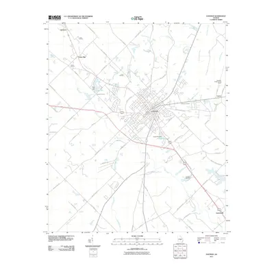
2011 Map of Eastman
USGS Topo · Published 2011About this map
Eastman serves as the central hub of this Dodge County landscape, where the convergence of regional highways and local roads like Pearl Bates Ave and Dodge Ave define the town's geometry. To the west, the rural character is punctuated by family and community landmarks such as Lockett Cemetery, Harrell Cemetery, and Orphans Cemetery, providing valuable data points for those tracing local family lineages. The water systems of Sugar Creek and Gum Swamp Creek wind through the territory, feeding into engineered sites like Tripps Lake and Harrell Pond. These water bodies and their associated dams, such as Tripps Lake Dam, illustrate the local management of the Georgia drainage basins. Further south, the settlement of Godwinsville and the industrial activity along J Hemphill Industrial Blvd highlight the mix of agricultural heritage and modern development.
Find a feature on this map
63 named features on this map. Tap any name to fly to it.
Don’t see what you’re looking for? This feature index may not catch every label — zoom into the map to look around manually.
Map Details
Editions of this 2011 Eastman Map
This is the sole edition of this map. No revisions or reprints were ever made.
Other maps of this area

1956 · Cochran
USGS Topo · 1:62,500

1957 · Macon
USGS Topo · 1:250,000

1958 · Macon
USGS Topo · 1:250,000

1964 · Macon
USGS Topo · 1:250,000

1972 · Eastman
USGS Topo · 1:24,000

1972 · West Of Eastman
USGS Topo · 1:24,000

1972 · Jay Bird Springs
USGS Topo · 1:24,000

1972 · Abbeville North
USGS Topo · 1:24,000
1972 · Milan
USGS Topo · 1:24,000

1972 · Lake Cypress
USGS Topo · 1:24,000