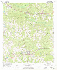
1972 Map of Milan
USGS Topo · Published 1975About this map
Milan and Chauncey anchor this survey of the South Georgia wiregrass region, where the Dodge Co Telfair Co boundary cuts across a landscape defined by its creek-fed wetlands and rural social hubs. The settlement of Suomi stands along the Southern railroad in the north, while the Seaboard Coast Line tracks serve the southern portion of the quadrangle. This map provides a detailed look at the rural religious and educational network of the early 1970s, featuring landmarks like Antioch Number Two Sch and Antioch Cem.
Find a feature on this map
23 named features on this map. Tap any name to fly to it.
Don’t see what you’re looking for? This feature index may not catch every label — zoom into the map to look around manually.
Map Details
Editions of this 1972 Milan Map
This is the sole edition of this map. No revisions or reprints were ever made.
Other maps of this area

1953 · Waycross
USGS Topo · 1:250,000

1957 · Macon
USGS Topo · 1:250,000

1958 · Macon
USGS Topo · 1:250,000

1958 · Waycross
USGS Topo · 1:250,000

1964 · Macon
USGS Topo · 1:250,000

1972 · Eastman
USGS Topo · 1:24,000

1972 · Cooks Still
USGS Topo · 1:24,000

1972 · Mc Rae NW
USGS Topo · 1:24,000

1972 · Jay Bird Springs
USGS Topo · 1:24,000
1972 · Mc Rae
USGS Topo · 1:24,000