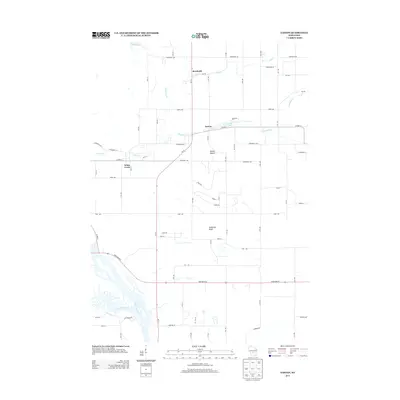
2013 Map of Easton
USGS Topo · Published 2013About this map
Brookside and Easton anchor this central Wisconsin landscape, where agricultural fields are defined by a strict grid of numeric avenues and alphabetically named roads. The terrain is punctuated by distinctive geological features such as Easton Mound and Anderson Bluff, providing vertical relief against the surrounding flats. Water defines the southwestern corner of the map, where the Wisconsin River meets the Lemonweir River in a complex of sandbars and shifting channels.
Find a feature on this map
59 named features on this map. Tap any name to fly to it.
Don’t see what you’re looking for? This feature index may not catch every label — zoom into the map to look around manually.
Map Details
Editions of this 2013 Easton Map
This is the sole edition of this map. No revisions or reprints were ever made.
Other maps of this area

1901 · The Dells
USGS Topo · 1:62,500

1902 · Briggsville
USGS Topo · 1:62,500

1957 · Wisconsin Dells
USGS Topo · 1:62,500

1957 · Madison
USGS Topo · 1:250,000

1958 · Briggsville
USGS Topo · 1:62,500

1960 · Madison
USGS Topo · 1:250,000

1961 · Oxford
USGS Topo · 1:62,500

1961 · Adams
USGS Topo · 1:62,500
1975 · Wisconsin Dells NW
USGS Topo · 1:24,000

1975 · Wisconsin Dells NE
USGS Topo · 1:24,000