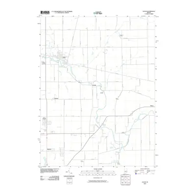
2010 Map of Eaton
USGS Topo · Published 2010About this map
The Mississinewa River winds through the heart of northern Delaware County, anchoring the town of Eaton and the historic settlement of Granville. This 2010 survey illustrates a landscape defined by organized drainage and rural cemetery sites, including Union Cemetery, Leaird Cemetery, and Black Cemetery. The grid of county roads, such as N 400 E Rd and E 800 N Rd, connects smaller hubs like Shideler and Royerton to the agricultural surroundings. Extensive water management is evident through numerous man-made features like Rees Ditch, Swearengen Ditch, and Bosman Ditch, which channel water toward the primary river and its tributaries, Mud Creek and Killbuck Creek.
Find a feature on this map
63 named features on this map. Tap any name to fly to it.
Don’t see what you’re looking for? This feature index may not catch every label — zoom into the map to look around manually.
Map Details
Editions of this 2010 Eaton Map
This is the sole edition of this map. No revisions or reprints were ever made.
Other maps of this area

1952 · Muncie East
USGS Topo · 1:24,000

1952 · Farmland
USGS Topo · 1:24,000

1952 · Muncie West
USGS Topo · 1:24,000

1953 · Muncie
USGS Topo · 1:250,000

1956 · Muncie
USGS Topo · 1:250,000

1960 · Pennville
USGS Topo · 1:24,000

1960 · Hartford City East
USGS Topo · 1:24,000

1960 · Eaton
USGS Topo · 1:24,000

1960 · Wheeling
USGS Topo · 1:24,000
1960 · Redkey
USGS Topo · 1:24,000