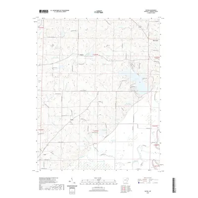
2020 Map of Eaton
USGS Topo · Published 2020About this map
Lake Charles dominates the eastern landscape of this Lawrence County terrain, where a sophisticated network of water management features like Flat Cr Site Two Reservoir and Flat Cr Site Six Reservoir support the local drainage system. Small settlements and crossroads define the rural character of the area, including Denton, Eaton, and Lynn, each connected by a grid of numbered Lawrence County roads. Genealogists will find a significant concentration of family and community burial grounds, including Old Bethel Cem and Powhatan Cem, which are scattered among the ridges and creek bottoms. The southern portion of the map is defined by low-lying wetlands and sluggish water bodies such as Sawlog Slough, Hill Slough, and Brushy Pond, illustrating the transition from upland ridges to the bottomlands near the Black River.
Find a feature on this map
95 named features on this map. Tap any name to fly to it.
Don’t see what you’re looking for? This feature index may not catch every label — zoom into the map to look around manually.
Map Details
Editions of this 2020 Eaton Map
This is the sole edition of this map. No revisions or reprints were ever made.
Other maps of this area

1932 · Strawberry
USGS Topo · 1:62,500

1934 · Powhatan
USGS Topo · 1:62,500

1935 · Powhatan
USGS Topo · 1:62,500

1935 · Alicia
USGS Topo · 1:62,500

1935 · Strawberry
USGS Topo · 1:62,500

1941 · Strawberry
USGS Topo · 1:62,500

1953 · Memphis
USGS Topo · 1:250,000

1955 · Strawberry
USGS Topo · 1:24,000

1956 · Memphis
USGS Topo · 1:250,000

1957 · Poplar Bluff
USGS Topo · 1:250,000