
1985 Map of Eau Claire
USGS Topo · Published 1985About this map
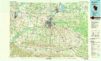
The Chippewa River serves as the central artery for this mid-1980s western Wisconsin landscape, winding through a network of dams and extensive floodplains. The urban centers of Eau Claire and Chippewa Falls dominate the central corridor, while Menomonie anchors the western edge near Lake Menomin. This period shows the region's established industrial and transit infrastructure, including the Chicago and North Western rail lines and the development around Lake Wissota. Beyond the cities, the map reveals a complex terrain of river valleys such as Tiffany Valley and German Valley, alongside protected spaces like Hoffman Hills State Park. The geography transitions from the dense street grids of Altoona and Augusta to the sprawling Chippewa Bottoms, reflecting a landscape deeply shaped by the convergence of the Eau Claire River and the Red Cedar River with the primary Chippewa waterway.
Find a feature on this map
163 named features on this map. Tap any name to fly to it.
Don’t see what you’re looking for? This feature index may not catch every label — zoom into the map to look around manually.
Map Details
Editions of this 1985 Eau Claire Map
2 editions found
Other maps of this area

1924 · Black River Falls
USGS Topo · 1:62,500

1926 · Black River Falls
USGS Topo · 1:62,500

1926 · Whitehall
USGS Topo · 1:62,500

1927 · Blair
USGS Topo · 1:62,500

1927 · Strum
USGS Topo · 1:62,500

1929 · Whitehall
USGS Topo · 1:62,500

1929 · Durand
USGS Topo · 1:62,500

1930 · Strum
USGS Topo · 1:62,500

1932 · Gilmanton
USGS Topo · 1:62,500

1932 · Wabasha
USGS Topo · 1:62,500