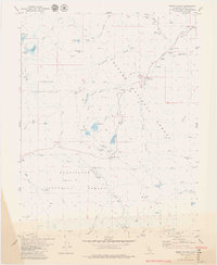
1979 Map of Ebbetts Pass
USGS Topo · Published 1979About this map
Silver Mountain (Site) serves as a silent reminder of the mid-19th-century silver rush that briefly transformed this high-altitude landscape. Located near the headwaters of Silver Creek, the site is surrounded by numerous lode mining remnants including the Lady Franklin Mine, Exchequer Mine, and the Isabella Tunnel. The presence of the Silver Mtn Mineral Mon highlights the area's significance to regional surveying and mineral claims history.
Find a feature on this map
65 named features on this map. Tap any name to fly to it.
Don’t see what you’re looking for? This feature index may not catch every label — zoom into the map to look around manually.
Map Details
Editions of this 1979 Ebbetts Pass Map
4 editions found
Other maps of this area

1889 · Markleeville
USGS Topo · 1:125,000

1891 · Markleeville
USGS Topo · 1:125,000

1893 · Markleeville
USGS Topo · 1:125,000

1896 · Dardanelles
USGS Topo · 1:125,000

1898 · Dardanelles
USGS Topo · 1:125,000

1948 · Walker Lake
USGS Topo · 1:250,000

1956 · Topaz Lake
USGS Topo · 1:62,500

1956 · Markleeville
USGS Topo · 1:62,500

1956 · Dardanelles Cone
USGS Topo · 1:62,500

1956 · Sonora Pass
USGS Topo · 1:62,500