
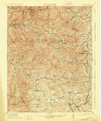
1914 Map of Eccles
USGS Topo · Published 1914About this map
Eccles and the surrounding coalfields of the Kay Moor Mountain region are documented here during a period of industrial expansion. The map illustrates the convergence of terrain and transportation, where the C and O RR and the Virginian and Kanawha River RR trace the winding valleys of Paint Creek and the Clear Fork. The landscape is dotted with small settlements like Pax, Kingston, and Dorothy, many established near early operations such as Cabin Creek Coal.
Find a feature on this map
130 named features on this map. Tap any name to fly to it.
Don’t see what you’re looking for? This feature index may not catch every label — zoom into the map to look around manually.
Map Details
Editions of this 1914 Eccles Map
2 editions found
Other maps of this area

1891 · Oceana
USGS Topo · 1:125,000

1891 · Raleigh
USGS Topo · 1:125,000

1893 · Oceana
USGS Topo · 1:125,000

1897 · Kanawha Falls
USGS Topo · 1:125,000

1897 · Raleigh
USGS Topo · 1:125,000

1898 · Oceana
USGS Topo · 1:125,000

1899 · Charleston
USGS Topo · 1:125,000

1900 · Kanawha Falls
USGS Topo · 1:125,000

1901 · Kanawha Falls
USGS Topo · 1:125,000

1902 · Raleigh
USGS Topo · 1:125,000