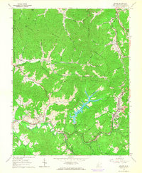
1965 Map of Eccles
USGS Topo · Published 1966About this map
The mountain terrain of Raleigh County is defined here by the winding coal and rail infrastructure of the mid-1960s. Eccles serves as a focal point for the region's industrial activity, featuring a Tipple Conveyor and a nearby Mine Dump, illustrating the intensive extraction processes of the era. The landscape is a complex network of ridges including Clear Fork Mountain and Flat Mountain, where small communities like Glen Daniel and Fairdale are connected by the Chesapeake and Ohio and Norfolk and Western railroads.
Find a feature on this map
84 named features on this map. Tap any name to fly to it.
Don’t see what you’re looking for? This feature index may not catch every label — zoom into the map to look around manually.
Map Details
Editions of this 1965 Eccles Map
3 editions found
Other maps of this area

1891 · Raleigh
USGS Topo · 1:125,000

1897 · Raleigh
USGS Topo · 1:125,000

1902 · Raleigh
USGS Topo · 1:125,000

1911 · Marshes
USGS Topo · 1:48,000

1911 · Flattop
USGS Topo · 1:48,000

1911 · Beckley
USGS Topo · 1:48,000

1912 · Mullens
USGS Topo · 1:62,500

1913 · Beckley
USGS Topo · 1:62,500

1914 · Eccles
USGS Topo · 1:62,500

1914 · Flattop
USGS Topo · 1:62,500