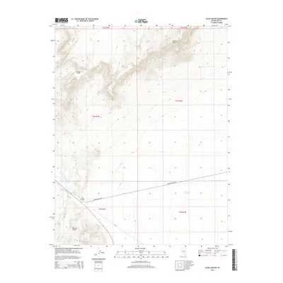
2014 Map of Echo Canyon
USGS Topo · Published 2014About this map
Big Fault Ridge and the southern reaches of the Pancake Range dominate this high-desert landscape in central Nevada. The terrain is defined by dramatic elevation shifts where the mountains meet the wide basin, through which Hot Cr flows toward the east. Human infrastructure is sparse, concentrated primarily along the southern corridor where Railroad Valley Rd traverses the valley floor. Near the junction of the Reveille Range, the map reveals Twin Springs and the Echo Canyon Reservoir, critical water features in an otherwise arid environment. This 2014 survey illustrates the contemporary balance of the region, showing how modern access roads like NF-415 navigate the complex topography of Echo Canyon and the surrounding township and range blocks.
Find a feature on this map
15 named features on this map. Tap any name to fly to it.
Don’t see what you’re looking for? This feature index may not catch every label — zoom into the map to look around manually.
Map Details
Editions of this 2014 Echo Canyon Map
This is the sole edition of this map. No revisions or reprints were ever made.
Other maps of this area

1956 · Lund
USGS Topo · 1:250,000

1956 · Tonopah
USGS Topo · 1:250,000

1959 · Tonopah
USGS Topo · 1:250,000

1960 · Lund
USGS Topo · 1:250,000

1962 · Tonopah
USGS Topo · 1:250,000
1967 · Lunar Crater
USGS Topo · 1:62,500
1967 · Buckwheat Rim
USGS Topo · 1:24,000
1967 · Chuck Wagon Flat
USGS Topo · 1:24,000
1968 · Reveille
USGS Topo · 1:62,500
1968 · The Wall
USGS Topo · 1:62,500