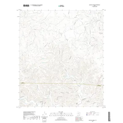
2019 Map of Echo Hill Ranch
USGS Topo · Published 2019About this map
Echo Hill Ranch serves as a central landmark in this portion of the Texas Hill Country, where the landscape is defined by the intersection of Kerr County and Bandera County. The drainage patterns here are complex, with narrow valleys and high ridges such as Zapata Ridge and the prominent White Bluff. Numerous waterways like Slippery Creek, Turtle Creek, and Johnson Creek carve through the limestone terrain, feeding into private impoundments including Ed Weyner Jr Ranch Lake and Brewington Creek Ranch Lake.
Find a feature on this map
64 named features on this map. Tap any name to fly to it.
Don’t see what you’re looking for? This feature index may not catch every label — zoom into the map to look around manually.
Map Details
Editions of this 2019 Echo Hill Ranch Map
This is the sole edition of this map. No revisions or reprints were ever made.
Other maps of this area
1894 · Kerrville
USGS Topo · 1:125,000
1954 · Llano
USGS Topo · 1:250,000
1954 · San Antonio
USGS Topo · 1:250,000
1955 · Llano
USGS Topo · 1:250,000
1956 · Tuff
USGS Topo · 1:62,500
1956 · Center Point
USGS Topo · 1:62,500
1956 · Llano
USGS Topo · 1:250,000
1957 · San Antonio
USGS Topo · 1:250,000
1964 · Diamond S Ranch
USGS Topo · 1:24,000
1964 · Echo Hill Ranch
USGS Topo · 1:24,000