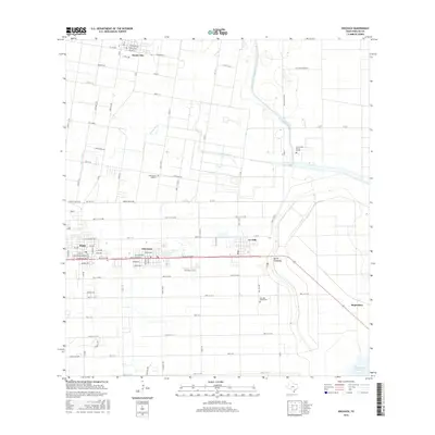
2016 Map of Edcouch
USGS Topo · Published 2016About this map
The agricultural landscape of eastern Hidalgo County is defined by a dense network of irrigation and drainage infrastructure, including the Main Supply Canal, the Donna Drain, and the expansive North Floodway. This 2016 survey captures the sister cities of Elsa and Edcouch along the southern corridor, where the grid of city streets like 5th Ave and E Ciro Caceres Ave gives way to the broad, mile-section rural roads of the Rio Grande Valley. Genealogists will find several notable burial grounds across this quadrangle, including Cementerio Anahuac, the San Jose Ranch Cem, and the uniquely named Cementerio de las Burras in the northeast. Small-scale aviation is represented by Skalitsky Airport, while the settlement of Monte Alto anchors the northern portion of the map near the Valley Acres Reservoir.
Find a feature on this map
63 named features on this map. Tap any name to fly to it.
Don’t see what you’re looking for? This feature index may not catch every label — zoom into the map to look around manually.
Map Details
Editions of this 2016 Edcouch Map
This is the sole edition of this map. No revisions or reprints were ever made.
Other maps of this area

1914 · San Juan
USGS Topo · 1:48,000

1916 · San Juan
USGS Topo · 1:62,500

1929 · Santa Rosa
USGS Topo · 1:24,000

1929 · La Feria
USGS Topo · 1:24,000

1933 · Santa Rosa
USGS Topo · 1:31,680

1936 · La Feria
USGS Topo · 1:31,680

1949 · Mc Allen
USGS Topo · 1:250,000

1953 · Brownsville
USGS Topo · 1:250,000

1954 · McAllen
USGS Topo · 1:250,000

1956 · Santa Rosa
USGS Topo · 1:24,000