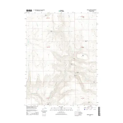
2014 Map of Eddies Garden
USGS Topo · Published 2014About this map
The high desert canyons of Eddies Garden and the surrounding Washoe County backcountry are defined by a critical network of water sources in this 2014 survey. This landscape, carved by the N Fork Buffalo Cr, W Fork Buffalo Cr, and Middle Fork Buffalo Cr, reveals the essential role of isolated springs in the Great Basin. Named points such as Stone Corral Spring, Cottonwood Spring, and Twin Springs suggest the historical reliance of ranchers and travelers on these reliable seeps. The presence of Buffalo Meadows and the namesake Eddies Garden indicate areas of relatively lush vegetation amidst the drainages of Cedar Canyon and Pauls Camp Canyon. Human infrastructure is sparse, limited primarily to unpaved routes like Buffalo Meadows Rd and Road 26006, which traverse the high-elevation terrain near Wrangler Canyon and Stockade Canyon.
Find a feature on this map
29 named features on this map. Tap any name to fly to it.
Don’t see what you’re looking for? This feature index may not catch every label — zoom into the map to look around manually.
Map Details
Editions of this 2014 Eddies Garden Map
This is the sole edition of this map. No revisions or reprints were ever made.
Other maps of this area

1886 · Granite Range
USGS Topo · 1:250,000

1894 · Granite Range
USGS Topo · 1:250,000

1955 · Lovelock
USGS Topo · 1:250,000

1959 · Lovelock
USGS Topo · 1:250,000
1980 · Buffalo Creek
USGS Topo · 1:24,000
1980 · Burnt Lake
USGS Topo · 1:24,000
1980 · Mixie Flat
USGS Topo · 1:24,000
1980 · Hole In The Ground
USGS Topo · 1:24,000
1981 · Eddies Garden
USGS Topo · 1:24,000
1981 · Gerlach
USGS Topo · 1:100,000