
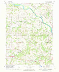
1968 Map of Eddyville
USGS Topo · Published 1971About this map
The Des Moines River carves a deep valley through this landscape, marking the convergence of Mahaska, Monroe, and Wapello counties. The area is defined by its industrial activity in the late 1960s, with extensive strip mines, quarries, and gravel pits flanking the river and the northern uplands near Givin. The settlement of Eddyville sits on the river's eastern bank, supported by a significant powerplant and the infrastructure of the Chicago and North Western railroad. Smaller communities like Lakonta (Truax) and rural landmarks such as Crane Cem and Bridgeport Cem provide points of interest for genealogists tracing family roots in this coal-rich region. A unique recreational feature, a Drag Strip, is visible near Lost Creek east of the river.
Find a feature on this map
39 named features on this map. Tap any name to fly to it.
Don’t see what you’re looking for? This feature index may not catch every label — zoom into the map to look around manually.
Map Details
Editions of this 1968 Eddyville Map
This is the sole edition of this map. No revisions or reprints were ever made.
Other maps of this area

1910 · Pella
USGS Topo · 1:62,500

1912 · Pella
USGS Topo · 1:62,500

1929 · Albia
USGS Topo · 1:62,500

1954 · Des Moines
USGS Topo · 1:250,000

1956 · Des Moines
USGS Topo · 1:250,000

1957 · Des Moines
USGS Topo · 1:250,000

1968 · University Park
USGS Topo · 1:24,000

1968 · Oskaloosa
USGS Topo · 1:24,000

1968 · Kirkville
USGS Topo · 1:24,000
1968 · Chillicothe
USGS Topo · 1:24,000