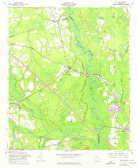
1958 Map of Eden
USGS Topo · Published 1977About this map
Ogeechee River and the winding Little Ogeechee River define the eastern wetlands of this Georgia landscape, while the Seaboard Coast Line railroad cuts a diagonal path through the timber and farm country of Bryan and Effingham counties. The settlement pattern is characterized by numerous country churches that anchor the rural communities, including Eldora Ch, Olive Branch Ch, and Sand Hill Ch. A significant concentration of community infrastructure appears near Blitchton, where a water tower and artesian wells supported local needs alongside the Miles Branch Ch.
Find a feature on this map
38 named features on this map. Tap any name to fly to it.
Don’t see what you’re looking for? This feature index may not catch every label — zoom into the map to look around manually.
Map Details
Editions of this 1958 Eden Map
2 editions found
Other maps of this area

1919 · Egypt
USGS Topo · 1:62,500

1920 · Pembroke
USGS Topo · 1:62,500

1920 · Meldrim
USGS Topo · 1:62,500

1921 · Brooklet
USGS Topo · 1:62,500

1939 · Egypt
USGS Topo · 1:62,500

1942 · Meldrim
USGS Topo · 1:62,500

1943 · Brooklet
USGS Topo · 1:62,500

1943 · Egypt
USGS Topo · 1:62,500

1947 · Savannah
USGS Topo · 1:250,000

1948 · Savannah
USGS Topo · 1:250,000