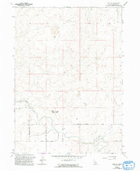
1964 Map of Eden NE
USGS Topo · Published 1992About this map
Cinder Butte rises as a prominent volcanic landmark in this high-desert landscape north of the Snake River, marking a region defined by agricultural engineering and geological extraction. The arrival of water through the Milner Gooding Canal transformed this arid Jerome County terrain into productive land, supported by an intricate network of irrigation infrastructure including a Flume and numerous wells. The map reveals the area's practical land use during the mid-to-late 20th century, with industrial and ranching features such as Cinder Pits, a large Feedlot, and an isolated Corral situated among the rocky outcrops. A straight grid of section-line roads like South Road and 600 South Road anchors the rural transit system, facilitating movement between the fields and the volcanic formations that dominate the northern horizon.
Find a feature on this map
12 named features on this map. Tap any name to fly to it.
Don’t see what you’re looking for? This feature index may not catch every label — zoom into the map to look around manually.
Map Details
Editions of this 1964 Eden NE Map
2 editions found
Other maps of this area

1954 · Pocatello
USGS Topo · 1:250,000

1955 · Twin Falls
USGS Topo · 1:250,000

1958 · Twin Falls
USGS Topo · 1:250,000

1958 · Pocatello
USGS Topo · 1:250,000

1964 · Burley SW
USGS Topo · 1:24,000

1964 · Burley NW
USGS Topo · 1:24,000

1964 · Eden
USGS Topo · 1:24,000

1964 · Milner
USGS Topo · 1:24,000

1964 · Hazelton NE
USGS Topo · 1:24,000

1964 · Hunt
USGS Topo · 1:24,000