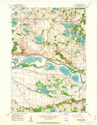
1954 Map of Eden Prairie
USGS Topo · Published 1963About this map
The Minnesota River carves a deep valley across this mid-century landscape, separating the developing uplands of Eden Prairie and Bloomington from the rural reaches of Eagle Creek to the south. In the years following World War II, this region remained a transition between agricultural land and growing suburban centers like Edina. The map preserves the locations of several educational and religious landmarks, including the Eden Prairie Church, Eden Prairie Cemetery, and two structures marked as School No 1 and School No 5.
Find a feature on this map
42 named features on this map. Tap any name to fly to it.
Don’t see what you’re looking for? This feature index may not catch every label — zoom into the map to look around manually.
Map Details
Editions of this 1954 Eden Prairie Map
2 editions found
Other maps of this area

1896 · Minneapolis
USGS Topo · 1:62,500

1901 · Minneapolis
USGS Topo · 1:62,500

1905 · Minnetonka
USGS Topo · 1:62,500

1907 · Minnetonka
USGS Topo · 1:62,500

1952 · Minneapolis South
USGS Topo · 1:24,000

1953 · Saint Paul
USGS Topo · 1:250,000

1954 · Hopkins
USGS Topo · 1:24,000

1954 · Bloomington
USGS Topo · 1:24,000

1954 · Eden Prairie
USGS Topo · 1:24,000

1954 · Minneapolis
USGS Topo · 1:62,500