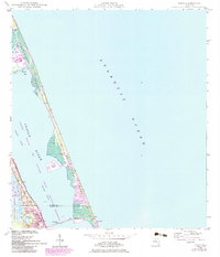
1948 Map of Eden
USGS Topo · Published 1983About this map
Hutchinson Island dominates this coastal survey, serving as a slender barrier between the Atlantic Ocean and the Indian River. This edition highlights a period of significant infrastructure development, most notably the Hutchinson Island Nuclear Power Plant (Under Construction) near Big Mud Creek. On the mainland, the Florida East Coast railway parallels the shoreline, passing through the established community of Eden and near Lake Eden.
Find a feature on this map
25 named features on this map. Tap any name to fly to it.
Don’t see what you’re looking for? This feature index may not catch every label — zoom into the map to look around manually.
Map Details
Editions of this 1948 Eden Map
3 editions found
Other maps of this area

1948 · Palm City
USGS Topo · 1:24,000

1948 · Ankona
USGS Topo · 1:24,000

1948 · St. Lucie Inlet
USGS Topo · 1:24,000

1948 · Eden
USGS Topo · 1:24,000

1949 · Fort Pierce
USGS Topo · 1:24,000

1950 · St. Lucie Inlet
USGS Topo · 1:24,000

1950 · Ankona
USGS Topo · 1:24,000

1950 · Fort Pierce
USGS Topo · 1:24,000

1950 · Palm City
USGS Topo · 1:24,000
1950 · Eden
USGS Topo · 1:24,000