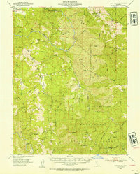
1952 Map of Eden Valley
USGS Topo · Published 1954About this map
Mt Sanhedrin anchors the southern portion of this rugged landscape within the Mendocino National Forest, where steep ridges and deep canyons define the transition between the Eel River and high interior peaks. The 1952 field survey shows a landscape dominated by livestock ranching and wildland transit, centered on the Eden Valley Ranch and the open pastoral ground of Eden Valley. Movement through the backcountry relied on established routes like the Thatcher Trail and Jack Hall Trail, which connected isolated landmarks such as Four Pines (Site) and Sportsman Glade. The northern reach includes a portion of Round Valley, while the central terrain is marked by distinctive geological features like Impassable Rock and Thatcher Butte. This era represents the mid-century forest management period before modern highway development significantly altered local access.
Find a feature on this map
90 named features on this map. Tap any name to fly to it.
Don’t see what you’re looking for? This feature index may not catch every label — zoom into the map to look around manually.
Map Details
Editions of this 1952 Eden Valley Map
4 editions found

Other maps of this area

1920 · Covelo
USGS Topo · 1:62,500

1922 · Willits
USGS Topo · 1:62,500

1922 · Hullville
USGS Topo · 1:62,500

1926 · Covelo
USGS Topo · 1:62,500

1929 · Eden Valley
USGS Topo · 1:62,500

1942 · Willits
USGS Topo · 1:62,500

1943 · Pomo
USGS Topo · 1:62,500

1944 · Willits
USGS Topo · 1:62,500

1951 · Lake Pillsbury
USGS Topo · 1:62,500

1951 · Laytonville
USGS Topo · 1:62,500