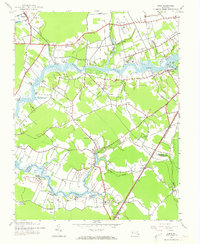
1942 Map of Eden
USGS Topo · Published 1973About this map
The Wicomico River and Wicomico Creek define this rural landscape of the Eastern Shore, as it appeared in the early 1940s. The map captures a transition from water-based transit to rail and road, evidenced by numerous historical landings and wharves such as Quantico Wharf, Patricks Landing, and Wagner Landing. The Pennsylvania railroad line cuts through the southeastern portion, passing through the settlement of Eden and near Loretto, while the historic Upper Ferry provides a crossing point for travelers on the river. Small inland communities like Allen, Siloam, and Catchpenny serve as anchors for the agricultural and marshy terrain. On the eastern edge near Shad Point, the Pine Bluff Sanitarium stands as a notable landmark overlooking Tonytank Creek. This 1942 survey offers a detailed look at the peninsula's settlement patterns before later development, showing the complex network of tidal guts and branches that structured local life.
Find a feature on this map
52 named features on this map. Tap any name to fly to it.
Don’t see what you’re looking for? This feature index may not catch every label — zoom into the map to look around manually.
Map Details
Editions of this 1942 Eden Map
2 editions found
Other maps of this area

1901 · Salisbury
USGS Topo · 1:62,500

1903 · Nanticoke
USGS Topo · 1:62,500

1903 · Deal Island
USGS Topo · 1:62,500

1942 · Monie
USGS Topo · 1:24,000

1942 · Wetipquin
USGS Topo · 1:24,000

1942 · Princess Anne
USGS Topo · 1:24,000

1942 · Mardela Springs
USGS Topo · 1:24,000

1942 · Eden
USGS Topo · 1:24,000

1942 · Hebron
USGS Topo · 1:24,000

1942 · Dividing Creek
USGS Topo · 1:24,000