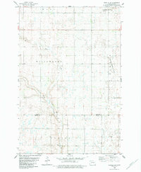
1982 Map of Edgeley SE
USGS Topo · Published 1983About this map
Maple River winds through the southwestern corner of this southeastern North Dakota landscape, carving a distinct path through a region defined by township sections and water-carved depressions. The map reveals the precise survey boundaries of several named districts, including Wano, Willowbank, and Valley, highlighting the organized agricultural structure of the late twentieth century. A prominent cultural landmark is the Finnish Cem located in the southern portion of the sheet, serving as a significant site for genealogical research and a marker of local heritage. To the east, the South Branch Cottonwood Creek meanders through Badger and Porter townships. The presence of a Gravel Pit near the river indicates the local extraction industry that supported road construction and maintenance across this prairie terrain during the early 1980s.
Find a feature on this map
11 named features on this map. Tap any name to fly to it.
Don’t see what you’re looking for? This feature index may not catch every label — zoom into the map to look around manually.
Map Details
Editions of this 1982 Edgeley SE Map
This is the sole edition of this map. No revisions or reprints were ever made.
Other maps of this area

1894 · Monango
USGS Topo · 1:62,500

1894 · La Moure
USGS Topo · 1:62,500

1894 · Fullerton
USGS Topo · 1:62,500

1895 · Lamoure
USGS Topo · 1:125,000

1896 · Edgeley
USGS Topo · 1:125,000

1918 · La Moure
USGS Topo · 1:125,000

1925 · Edgeley
USGS Topo · 1:125,000

1953 · Jamestown
USGS Topo · 1:250,000

1956 · Jamestown
USGS Topo · 1:250,000
1956 · Berlin
USGS Topo · 1:24,000
Featured Places
- Willowbank Hutterite Colony, ND
- Henrietta Township, ND
- Badger Township, ND
- Valley Township, ND
- Porter Township, ND