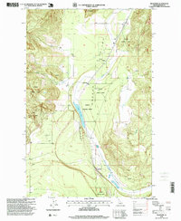
1996 Map of Edgemere
USGS Topo · Published 1999About this map
Hoodoo Lake and the surrounding Valley define this portion of Bonner County, where the transition between the Kaniksu National Forest and rural settlements is clearly delineated. Revised by the USDA Forest Service in the mid-1990s, this document captures a network of small communities and infrastructure including Edgemere, Vay, and the Edgemere Grange. The landscape is dominated by the north-south drainage of Hoodoo Creek, which passes through the narrow valley floor below the slopes of Horn Mountain. The mapping reveals a rural economy tied to the land, evidenced by numerous Gravel Pits and the proximity of the forest boundary. For researchers, the presence of localized place names like Harlem and Clagstone provides specific data points for tracing family history and property locations in this northern Idaho timber and ranching corridor.
Find a feature on this map
17 named features on this map. Tap any name to fly to it.
Don’t see what you’re looking for? This feature index may not catch every label — zoom into the map to look around manually.
Map Details
Editions of this 1996 Edgemere Map
This is the sole edition of this map. No revisions or reprints were ever made.
Other maps of this area

1901 · Sandpoint
USGS Topo · 1:125,000

1903 · Rathdrum
USGS Topo · 1:125,000

1911 · Priest Lake
USGS Topo · 1:250,000

1911 · Sandpoint
USGS Topo · 1:125,000

1913 · Priest Lake
USGS Topo · 1:250,000

1955 · Spokane
USGS Topo · 1:250,000

1958 · Spokane
USGS Topo · 1:250,000

1958 · Sandpoint
USGS Topo · 1:250,000

1961 · Spirit Lake East
USGS Topo · 1:24,000

1961 · Athol
USGS Topo · 1:24,000