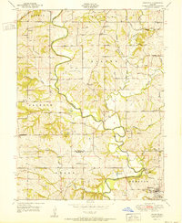
1951 Map of Edgerton
USGS Topo · Published 1951About this map
The Platte River meanders sharply through the heart of this landscape, forming the boundary between several townships including Preston, Green, and Jackson. This 1951 edition captures a mid-century rural infrastructure dominated by one-room schoolhouses and family-named cemeteries. Educational landmarks like the Rising Sun Sch and Arnoldsville School are scattered across the terrain, while the community of Edgerton serves as the primary settlement hub in the southeastern corner. Numerous small burial grounds, including the Union Mill Cem and Garrison Hill Cem, are preserved near the river's many tributaries. These creeks, such as Castile Creek and Malden Creek, feed into the river valley, illustrating the intricate drainage patterns that dictated the placement of local homesteads and churches like Davis Chapel and Frazer Ch.
Find a feature on this map
41 named features on this map. Tap any name to fly to it.
Don’t see what you’re looking for? This feature index may not catch every label — zoom into the map to look around manually.
Map Details
Editions of this 1951 Edgerton Map
2 editions found

Other maps of this area

1890 · Kansas City
USGS Topo · 1:125,000

1894 · Kansas City
USGS Topo · 1:125,000

1910 · Leavenworth
USGS Topo · 1:62,500

1914 · Smithville
USGS Topo · 1:62,500

1925 · Gower
USGS Topo · 1:62,500

1927 · Dearborn
USGS Topo · 1:62,500

1948 · Leavenworth
USGS Topo · 1:62,500

1950 · Kansas City
USGS Topo · 1:250,000
1950 · Smithville
USGS Topo · 1:62,500
1951 · Smithville
USGS Topo · 1:24,000