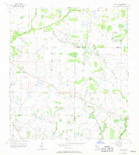
1956 Map of Edgeville
USGS Topo · Published 1971About this map
Edgeville and Sandy sit as small inland outposts in this 1956 planetable survey of the Florida interior. The landscape is defined by its low-lying drainage patterns, characterized by slow-moving water bodies like Wildcat Slough and Big Slough. These natural features, along with a network of shallow basins including Long Pond, Dog Pond, and Roxy Pond, illustrate the intricate hydrology of the Manatee and De Soto county lines before significant modern drainage alterations. Small seasonal tributaries such as Owen Creek and Sand Branch weave through the terrain, marking the rural character of the region during the mid-20th century. The survey captures the area at a quiet moment, documenting the primitive road network and localized naming conventions like Buzzard Roost Branch that grounded the community's geography.
Find a feature on this map
12 named features on this map. Tap any name to fly to it.
Don’t see what you’re looking for? This feature index may not catch every label — zoom into the map to look around manually.
Map Details
Editions of this 1956 Edgeville Map
3 editions found
Other maps of this area

1956 · Ona
USGS Topo · 1:24,000

1956 · Myakka City
USGS Topo · 1:24,000

1956 · Edgeville
USGS Topo · 1:24,000

1956 · Myakka City NW
USGS Topo · 1:24,000

1956 · Murdock NE
USGS Topo · 1:24,000

1956 · Myakka Head
USGS Topo · 1:24,000

1956 · Limestone
USGS Topo · 1:24,000

1956 · Nocatee
USGS Topo · 1:24,000

1956 · Murdock NW
USGS Topo · 1:24,000

1956 · Tampa
USGS Topo · 1:250,000