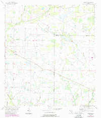
1956 Map of Edgeville
USGS Topo · Published 1987About this map
Edgeville sits at the heart of this mid-century survey, surrounded by the wet prairie and drainage networks of central Florida. The landscape is defined by the slow movement of water through systems like Owen Creek and Sand Branch, which weave through the low-lying terrain. Revisions from the mid-1980s are layered over the original 1956 topography, showing the progression of woodland and land use during a period of transition for rural Manatee and De Soto counties. The map captures the specialized agricultural and ranching character of the region, where surveyors carefully tracked minor elevation changes and water features to manage the productive but challenging Florida backcountry.
Find a feature on this map
3 named features on this map. Tap any name to fly to it.
Don’t see what you’re looking for? This feature index may not catch every label — zoom into the map to look around manually.
Map Details
Editions of this 1956 Edgeville Map
3 editions found
Other maps of this area

1956 · Ona
USGS Topo · 1:24,000

1956 · Myakka City
USGS Topo · 1:24,000

1956 · Edgeville
USGS Topo · 1:24,000

1956 · Myakka City NW
USGS Topo · 1:24,000

1956 · Murdock NE
USGS Topo · 1:24,000

1956 · Myakka Head
USGS Topo · 1:24,000

1956 · Limestone
USGS Topo · 1:24,000

1956 · Nocatee
USGS Topo · 1:24,000

1956 · Murdock NW
USGS Topo · 1:24,000

1956 · Tampa
USGS Topo · 1:250,000