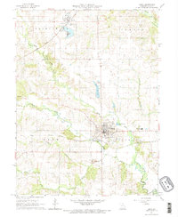
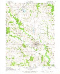
1965 Map of Edina
USGS Topo · Published 1966About this map
Edina serves as the focal point of this mid-1960s agricultural landscape, situated at the junction of several regional townships including Center, Lyon, and Liberty. The town's infrastructure is clearly defined, featuring a Water Tank, the Knox County High Sch, and the local Edina Golf Club near the Edina Reservoir. To the north, the smaller settlement of Baring sits along the tracks of the Atchison Topeka and Santa Fe railroad, while the Chicago Burlington and Quincy line cuts through the southern portion of the quadrangle.
Find a feature on this map
26 named features on this map. Tap any name to fly to it.
Don’t see what you’re looking for? This feature index may not catch every label — zoom into the map to look around manually.
Map Details
Editions of this 1965 Edina Map
2 editions found
Other maps of this area

1903 · Edina
USGS Topo · 1:125,000

1954 · Centerville
USGS Topo · 1:250,000

1957 · Centerville
USGS Topo · 1:250,000

1958 · Centerville
USGS Topo · 1:250,000
1965 · Edina SE
USGS Topo · 1:24,000
1965 · Knox City
USGS Topo · 1:24,000
1965 · Rutledge
USGS Topo · 1:24,000
1965 · Edina
USGS Topo · 1:24,000
1965 · Novelty
USGS Topo · 1:24,000

1965 · Greensburg
USGS Topo · 1:24,000