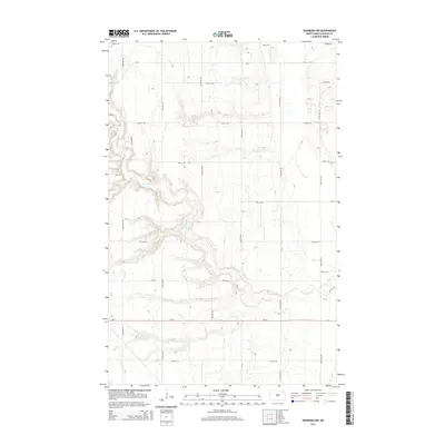
2014 Map of Edinburg NW
USGS Topo · Published 2014About this map
The S Br Park River snakes through this section of Walsh County, its winding course carving a distinct drainage pattern into the agricultural plateau of northeastern North Dakota. The landscape is defined by a rigid section-line grid of rural roads, including 75th St NE and 128th Ave NE, which provide access to the vast farmsteads of the region. The state highway ND-17 serves as the primary east-west corridor, cutting across the southern portion of the map. This 2014 survey documents the modern layout of the rural infrastructure, highlighting the intersection of paved county routes like CR-9 and CR-11 with a network of local gravel roads and the occasional Private Rd. The topography reveals the subtle but complex erosion patterns surrounding the river's south branch, providing a detailed view of the terrain before it flattens toward the Red River Valley to the east.
Find a feature on this map
23 named features on this map. Tap any name to fly to it.
Don’t see what you’re looking for? This feature index may not catch every label — zoom into the map to look around manually.
Map Details
Editions of this 2014 Edinburg NW Map
This is the sole edition of this map. No revisions or reprints were ever made.
Other maps of this area

1952 · Thief River Falls
USGS Topo · 1:250,000
1953 · Devils Lake
USGS Topo · 1:250,000

1956 · Thief River Falls
USGS Topo · 1:250,000
1956 · Devils Lake
USGS Topo · 1:250,000

1957 · Thief River Falls
USGS Topo · 1:250,000
1963 · Edinburg
USGS Topo · 1:24,000
1963 · Pleasant Valley
USGS Topo · 1:24,000
1963 · Gardar
USGS Topo · 1:24,000
1967 · Thief River Falls
USGS Topo · 1:250,000
1972 · Adams
USGS Topo · 1:24,000